Churchyard | St Thomas'
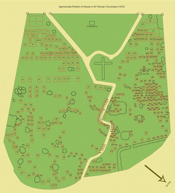
St Thomas’ has one of the largest Churchyards of any church in the City of Coventry. It is believed to contain about 2,400 grave spaces dating from 1847 to the present day. There are graves of the rich and famous like William Hillman the car maker, as well as many ordinary people. There are War graves going back to the Crimean War as well as more recent conflicts like the Vietnam War. There are some tall imposing Victorian stone crosses and vaults, there are hundreds of low-level modern gravestones, as well as a great many graves without any marker at all – because the family either chose or could not afford to erect a memorial. Much of the old churchyard was not noted on plans in the early years and we therefore do not know exactly where some of the early burials are as they would have been remembered in the lifetime of their loved ones but being without gravestones they are lost to memory over time. In 1979 a major survey of the old churchyard was made, with a plan drawn up from the remaining identifiable monuments.
Locating Graves in the Churchyard
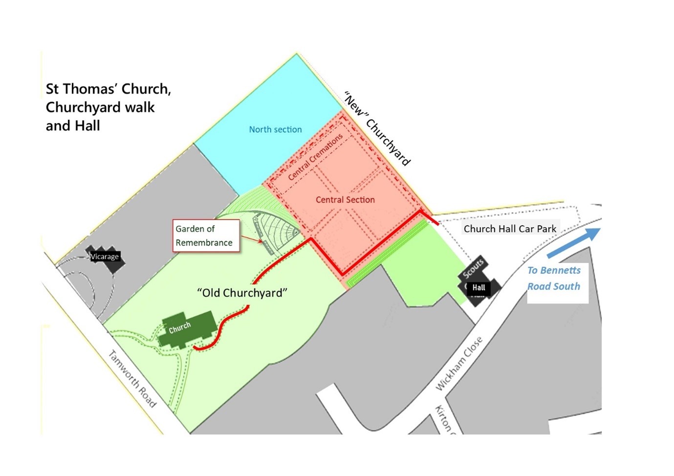
For administrative purposes the churchyard has 3 sections shown on the plans below, each area has its own numbering scheme to locate individual graves within it.
The Old Churchyard The oldest section with graves dating back to 1847, the year the church was consecrated.
The Central Section Consecrated at the beginning of the second World War. Cremation plots are at the North West end.
The North Section The most recent burials, this area does not allow any grave edgings to simplify the grass mowing.
We opened a Garden of Remembrance in a small area of the churchyard in 2019. This is a space where cremated remains are loose poured into a lawned area, and plaques are installed on a memorial wall.
Churchyard Maintenance
The churchyard was closed (by Order in Council of HM the Queen) in 2004. Since that time the maintenance of the churchyard has been the responsibility of Coventry City Council. The City Council are generally responsible for tasks like grass cutting, tree surgery and maintaining the paths (amongst other things). The maintenance of individual grave monuments remains the responsibility of the family of the deceased, the family legally owns the monument (though not the ground it rests on!).
General comments and questions about churchyard maintenance should be addressed to The Culture and Leisure Department at Coventry City Council (It would be appreciated if you could send a copy of any correspondence to the Parish Office so that we are aware of any issues.)
New Gravestones and Monuments
If you would like to introduce any sort of new gravestone or other monument, into the churchyard then you need to get permission first. For an ordinary grey stone on a family grave there is a very simple process, see the Funerals page of this website for more details.
The Old Churchyard
Many of the graves in this area were unmarked, more prominent or well-to-do families had burials nearer the Tamworth Road, often with grand monuments, while other families were buried further back, frequently without any stone. Although this may seem strange in the 21st Century, it was thought to be right and proper in the Victorian era to honour the upper classes like this. There was no detailed master plan for the churchyard at that time, it was merely expected that the Vicar (or the Sexton who tended the churchyard) would find a suitable plot on each occasion. Over the years it is therefore possible that some un-marked grave plots were inadvertently re-used.
To help with the maintenance of the area the Parochial Church Council asked the local Scout group to make a survey of the visible graves in 1979; this they kindly did. The plan below is based on their survey. Sadly, it cannot show all the un-marked graves, and it may never now be possible to exactly identify where every burial took place.
An example reference to a grave in the Old Churchyard might be: OCY 227 where OCY means Old Church Yard and number 227 is the individual grave.
Additional Information
Only monuments that were visible in 1979 are recorded in this survey. It is likely that most of the space between the visible graves was also used for burials but they have not been surveyed.
In 1979 when the survey was carried out there was NO vestry at the South East corner of the church building, when the Vestry was built the path was re-aligned. The path now passes between graves 89 and 90 and re-joins the old path line just before plot 107.
In 1989 the Galilee Room was built on the North side of the church, as part of the works carried out some graves were altered in this area (believed to be Nos 276, 284, 295, 296 & 301)
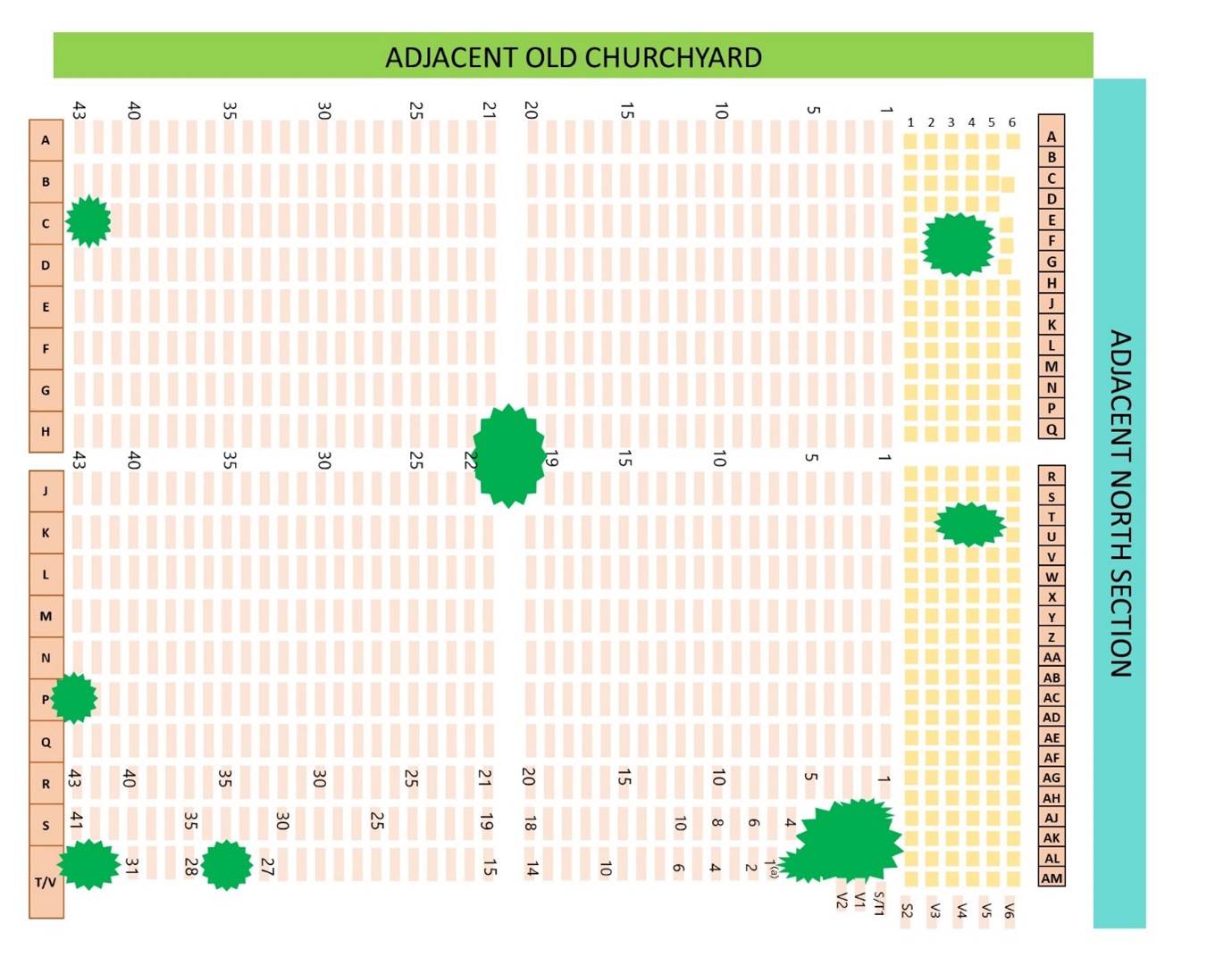
The Central Section
This land was given to the church and consecrated in 1939. In the first two rows there are buried victims of the blitz bombing in 1940 and 1941.
The rows of graves are “lettered” from the end nearest the church building, which is “Row A” – to the far end which is “Row T” (omitting rows “I” and “O”). Within each row they are numbered from 1 to 43, apart from Row S and T.
At the North West end there are 37 short rows of Cremation Plots marked by small headstones. The rows are lettered from “A” to “Z” then from “AA” to “AM” (omitting “I”, “O” and “AI”), within each row they are counted from 1 to 6 as shown on the plan.
An example reference to a grave in the Central Section might be: C B42 where C means Central Section, letter B is the Row and 42 is the individual grave in that row.
A reference to a cremation plot in the Central Section might be: CC W2 where CC means Central Section Cremation plots, the letter W refers to the row and 2 is the number of the grave in that row.
The North Section
Burials in this final extension began in the 1970s.
There are 2 rows of children’s graves along the Vicarage fence, then 22 rows of full-sized graves. In each of the full-sized grave rows the graves are lettered from A to Z and then AA (omitting I and O), as shown on the plan. Row 22 has only a small number of graves:
An example reference to a grave in the North Section might be: N 21D where N means North Section, number 21 is the Row Number and D is the individual grave in that row.
A reference to a child’s grave in the North Section might be: N Child2 where N means North Section, the word Child refers to the children’s Section and 2 is the number of the grave row.

